

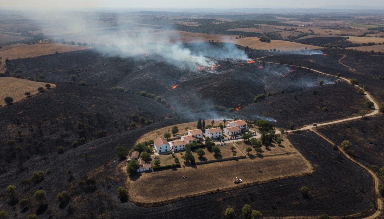
New drone footage captures sweeping burn scars across parts of Spain, offering a rare overhead view of fires that have disrupted communities and strained emergency crews. The video, recorded above smoke-choked hills and rural tracts, shows active flames, blackened fields, and standing homes on the edge of scorched land. It arrives as firefighters race to protect towns and farmland during a peak fire period.
Emergency workers have used the aerial views to chart fire fronts and to plan evacuations. Local officials said the images help assess threats to villages and power lines. The footage provides the public with a clear sense of scale and the speed at which the fire lines move.
“Drone video shows the extent of the Spain wildfires.”
Background: A Dry and High-Risk Season
Spain faces intense wildfire risk during hot, dry months. Prolonged heat, low humidity, and gusty winds set the stage for fast spread. Land abandonment in rural zones has also left more fuel in forests and scrublands.
In 2022, Spain recorded more than 300,000 hectares burned, according to the European Forest Fire Information System. That figure ranked among the highest in Europe that year. Scientists link longer fire seasons to rising temperatures and frequent droughts across the Mediterranean.
Officials say firefighting budgets now include aerial tools, fuel breaks, and public alerts. But rugged terrain and shifting winds still complicate control efforts, especially during overnight flare-ups.
What the Aerial Video Reveals
The drone sequence tracks fire lines creeping over ridges and through valleys. Plumes rise from ravines where access by road appears limited. Patches of green sit next to ash, showing where crews stopped the advance or where topography slowed it.
Emergency services often use drones to scout hazardous zones that aircraft cannot reach safely. Thermal cameras can spot hotspots through smoke. That data guides bulldozer lines and backburns. It also reduces risk to ground teams who must avoid sudden shifts in flame direction.
- Rapid mapping of active fronts helps time evacuations.
- Heat signatures identify hidden embers after the front passes.
- High-resolution imagery supports damage assessments for recovery.
Impact on Communities and Land
The footage shows farms bordered by charred scrub, a sign of tough choices made to prioritize people and homes. Rural economies face losses from damaged orchards, vineyards, and grazing land. Smoke affects air quality in nearby towns, raising health concerns for older residents and outdoor workers.
Conservation groups warn that repeated fires can degrade soils and increase erosion. Burned slopes risk flash floods when rain finally returns. Replanting native species and managing regrowth will take years and steady funding.
Emergency Response and Next Steps
Authorities typically coordinate ground crews, water-dropping aircraft, and local volunteers. Drone operators feed live images to command posts. Firefighters decide where to deploy assets, when to clear roads, and which neighborhoods to protect.
Experts recommend measures that reduce future risk. These include thinning overgrown areas near towns, maintaining firebreaks, and educating residents on defensible space. Insurance providers and mayors often support early-season fuel management to avoid costlier disasters later.
The European Union has also expanded a shared fleet of firefighting aircraft in recent summers. Cross-border cooperation helps when multiple countries face fires at the same time. Spain has drawn on these resources during extreme weeks.
What to Watch in the Coming Weeks
Meteorologists monitor heat waves, wind patterns, and soil moisture. Any rise in temperatures or change in wind could test current fire lines. Rain could offer relief, but lightning can also start new fires in dry fuel.
Analysts will examine the drone images to refine fire behavior models. Better models can improve evacuation timing and resource placement. Local councils will use the damage mapping to prioritize road repair, utility checks, and aid to farmers.
The new drone video offers a stark view of the challenge facing Spain this season. It also shows how technology can help protect lives and property when minutes matter. As crews push to contain the blazes, officials will weigh how to scale preventive work before the next heat wave. The coming days will show whether cooler nights and calmer winds give firefighters the upper hand, or if fresh flare-ups force new evacuations and longer battles ahead.

Kirstie a technology news reporter at DevX. She reports on emerging technologies and startups waiting to skyrocket.